

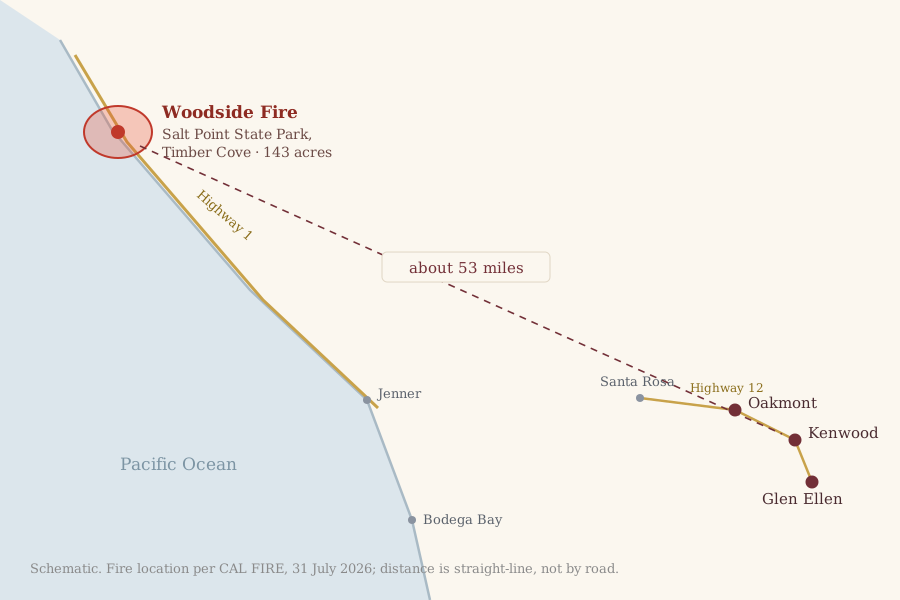
A wildfire is burning in heavy redwood timber on the Sonoma coast, with Highway 1 closed and one zone under evacuation order. It is some 53 miles from Kenwood, but its smoke has spread inland, and air quality across the region reached “very unhealthy” on Friday.
This report reflects official information as of Friday, July 31, around 9:15 a.m. An active fire changes by the hour. For live information use CAL FIRE’s incident page, SoCoEmergency and Watch Duty. If you are in or near an evacuation zone, follow the Sheriff’s Office, not this newspaper.
The Woodside Fire started on Thursday afternoon, July 30, in the 24000 block of Highway 1 near Timber Cove, on the west side of the highway inside Salt Point State Park. CAL FIRE put it at 142.6 acres and 30% contained in its Friday morning update, up from roughly 100 acres when the first evacuation order went out the previous afternoon. Crews gained ground overnight, taking containment from nothing to 30% between Thursday evening and Friday morning.
It is burning in heavy timber, some of it redwood, which holds fire longer than the grass and brush that carry most of the valley’s summer starts. Northwesterly winds of 10 to 15 mph, gusting to about 25, pushed the head of the fire southeast on Thursday. No cause has been announced.
Evacuations and closures
The Sonoma County Sheriff’s Office issued an evacuation order for zone SON-1D1 at about 4 p.m. on Thursday. The zone is the coastal strip between Fort Ross and the north end of Salt Point, taking in Timber Cove, Walsh Landing, Seaview and Stump Beach, some 350 households. An evacuation warning covers the neighboring inland zone SON-1D2, about 265 households. The Woodside and Gerstle Cove campgrounds inside Salt Point State Park were cleared.
Highway 1 is closed between Stewarts Point Skaggs Springs Road and Timber Cove Road. That makes for a long detour, because this stretch of coast has no parallel route. A temporary evacuation point was opened at Laguna High School, 7050 Covey Road, Forestville.
Neither CAL FIRE nor local coverage had reported any injuries or destroyed structures as of Friday morning. That is an absence of reports rather than an all-clear, and early figures on any fire are provisional.
What it means here
Salt Point is about 53 miles from Kenwood in a straight line, 56 from Glen Ellen and 49 from Oakmont, with the whole of the coast range in between. No evacuation zone is within many miles of the three towns, and no red flag warning is in effect for Sonoma County.
The smoke is what reaches us. The Bay Area Air District’s monitor at Santa Rosa recorded fine-particulate air quality of AQI 211 on Friday, in the “very unhealthy” band. The station is nine miles from Kenwood and the nearest official one to the valley. It read 165, “unhealthy,” on Thursday. Sonoma County’s health officer has issued an air quality advisory warning that parts of the county may see “very unhealthy” or “hazardous” conditions.
The official forecast has Saturday at AQI 152, still “unhealthy,” before conditions ease to moderate on Sunday and Monday and back to good by Tuesday.
Correction: An earlier version of this report put the valley’s air at around AQI 50 and said healthy people would notice nothing. That was wrong, and we have replaced it. Those figures came from a gridded forecast model that, as we discovered while reporting the follow-up, was not resolving the smoke plume at all. It returned nearly identical readings for the whole county, including at the fire itself. The numbers above now come from the Bay Area Air District’s monitors. There is still no ground-level monitor in Sonoma Valley proper, so Santa Rosa is the closest real reading we have. If you can smell smoke, believe your nose.
With air in this range, the county’s guidance is to stay indoors with windows and doors shut, set air conditioning and car ventilation to recirculate, keep the fresh-air intake closed and stay hydrated. The guidance also says to avoid anything that adds smoke or dust, such as mowing, leaf blowing, barbecuing or wood fires. Older adults, pregnant women, children and anyone with heart or lung conditions are the most affected. A cloth or surgical mask does little against fine particulates, while a well-fitted N95 or P100 does.
Where to get real-time information
The CAL FIRE incident page has acreage, containment and official updates, and SoCoEmergency has evacuation zones and shelters. SoCoAlert sends warnings to your phone, and registering takes about five minutes. Watch Duty, free and run by volunteers with scanner access, remains the fastest source most people in this county use. Our own fire, weather and water dashboard carries live air quality, the fire-weather forecast and burn status for the valley, refreshed through the day.
Sources: CAL FIRE incident data, retrieved July 31, 2026; Sonoma County SoCoEmergency; reporting by the Sonoma Index-Tribune and the Press Democrat on the evacuation zones and highway closure; air-quality readings and forecasts from the AirNow reporting-area file (Bay Area Air District observations and forecasts); distances calculated from published coordinates.